
Real Time Information
Monitoring, analyzing, and updating continuously real time weather data.
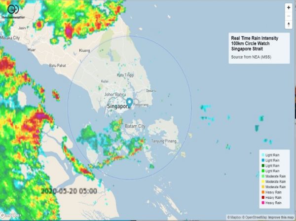
Data source from NEA (MSS). For the updated Web App display of real time Rain Intensity in the Singapore Strait, click here.
Tropical Squall Monitoring and Forecasting
Production of accurate severe weather nowcasting and warnings.
In the process of Alerting in a short period of time the High probability that Hazardous Weather Conditions are about to affect the operating area, Real Time Monitoring is an essential task which can be supported by powerful Advanced Analysis tools to assist in increasing reliability and accuracy during the assessment of such upcoming harsh weather.
Tropical Mesoscale Convective System (MCS) life cycle imposes not to rely only on model output due to minimum time needed to integrate all the variables for modelling and calculation. Thunderstorm, Squalls, Heavy Rain related to active convective systems generally develop, then reach maturity, before dissipating within few kilometers and within few hours. Hence, Real Time Data updated continuously will help to capture at the early stage any formation, movement and intensity to be reported in due time to end users for Risk mitigation purposes and severe conditions preparedness.
The Tropical Squall Lines are described as very active lines of convective cells along its major axis that the analyst must identify. The passage of the Squall line will be visually announced by the formation of some distinct roll cloud then followed by sharp wind increase possibly reaching extreme value around 100km/h. Immediately after the Surface Squall there will be a first period of intense heavy rain (possibly up to extreme around 60mm/h) then a period of lower intensity but steady rainfall before dissipating at the final stage.


 SRI product showing the maximum value of surface rainfall intensity of the first squall line system over South Sumatra region at 12.30 UTC, (b) SRI product showing the maximum value of surface rainfall intensity of the third squall line system over Java sea, near Kalimantan at 22.30 UTC. Source from OP Conf. Series publication.")
Squalls can lead to very bad damages for people, industrial assets, aeronautical and shipping operations.
Global MeteOcean has been working continuously to improve understanding of Squalls across various local patterns around the world using all the available data from deployed sensors in the area of interest, so we help to mitigate Risk and limit as much as possible the impact of Squalls by accurately forecasting their development and alert while we understand the potential damages on customer’s specific projects.
This will drive the various options of solutions to be advised through thescreenweather smart platform, in the view of providing the best exploitable and readable information for end users:
- Real Time Monitoring
- Sever Weather, Squall
- Nowcasting, Forecasting
- Intensity / Severity
- Tracking, Probability area
- Weather Alert, Notifications
- Weather Data display
- Weather Indicators
- Operational Limits
- Survivability Limits
- Impact Prediction (Area, Population, Assets)
Do not hesitate to contact us for more information and customized advice.
References :
The Structure of Tropical Sumatra Squalls (Man-Yau Chan) ResearchGate
Mesoscale Meteorology and Forecasting by Peter S. Ray (AMS)